Palestine Memories:
Palestine in 1900
About the Collection

Palestine Seen Through the Stereoscope in 1900 AD
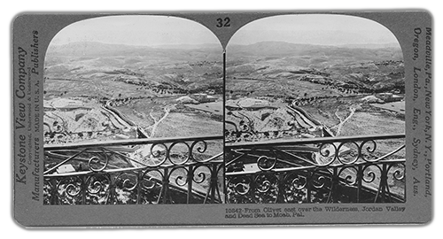
These photographs are part of a collection of nearly 200 images of Palestine taken circa 1900 and first published in 1914. Originally, these images were meant to be viewed using a ‘stereoscope’, an instrument that shows each eye a slightly different view of the image. The effect is to make the image become three-dimensional, so that the viewer feels that he or she has entered a real scene, instead of looking at a photograph.
The stereoscope was very popular in America in the late 1800s and early 1900s, before cinema became widely available. Particularly popular were collections of images from other parts of the world which allowed people to have an experience of far-away places without having to actually go there.
This Palestine collection (there were other, similar, collections), known as ‘Traveling in the Holy Land through the Stereoscope’, was the work of two Americans, Charles Foster Kent and Jesse Lyman Hurlbut, who travelled the length and breadth of Palestine at the close of the 19th century taking these photographs. As observant Christians, Kent and Hurlbut had an additional goal in taking the photographs. They were part of a popular trend of trying to ‘prove’ Christian and Old Testament history by visiting and studying the Holy Land. Because the history of Palestine was so central to Christianity this collection took on an importance that similar collections of India or Chile did not have. The idea was to use the photos to bring to life the people and landscapes that most Americans only knew from the Bible. In this way, Christian Americans could have a more intimate understanding of the ‘Holy Land’, and the characters and scenes depicted in the Old and New Testaments.
In order to achieve this, Kent and Hurlbut essentially ignored the life and culture they found in Palestine. What they saw and experienced was a facsimile of ancient times, with the modern inhabitants standing in for the ancient Hebrew and Canaanite tribes. One can say that they were lucky in one way: most rural Palestinians in 1900 still dressed in traditional clothing that was very close to their conception of ancient Palestinian attire. The captions chosen for the photos made reference, not to the actual place names, but to Biblical names related by custom and tradition to the locations. Thus, it was easy for Kent and Hurlbut, and for Americans generally, to look at these images of 1900 but feel like they were viewing scenes in ancient Palestine.
Although he may never have encountered this collection, it is in fact a startling example of Edward Said’s thesis that the West is generally unable to see the East except as a reflection of its own myths, desires and unconscious archetypes. Certainly, it is true that, when it comes to the ‘Holy Land’, Westerners have traditionally found it difficult –or impossible – to separate reality from the foundational myths and legends of our culture.
Despite these important shortcomings, we owe a debt of gratitude to Kent and Hurlbut. Without realizing what they were doing, they preserved and cataloged for all time a record of Palestinian life before the turmoil and upheaval that was to come – what Palestinians call the Naqba, or ‘disaster’. At the time these photos were taken, the long-established Palestinian Jewish community constituted about 8% of the total population.


Another example of using the present to recreate the past; a fountain in Nazareth.
Forty years or so later, after decades of immigration and just before the creation of the state of Israel, they still only constituted about 35%. What changed the balance was the flood of Jews escaping Europe after the Holocaust and the 1948 war that led to the creation of Israel, and during which approximately 700,000 Palestinians were driven from their homes and into exile. According to Israeli ‘New Historians’ such as Benny Morris and Ilan Pappe, somewhere between 400 and 600 Palestinian Arab towns and villages were destroyed or emptied and taken over during the 1948 war. Former deputy mayor of Jerusalem and eminent Israeli journalist and historian Meron Benvenisti has documented the process by which towns, villages, forests, rivers and countless other sites were obliterated from the map and a new geography of Palestine created, largely based upon Biblical place names. Thus, in an unexpected way, the fictional Palestine depicted in these photos in many cases prefigured the wholesale transformation of a land and a people that was to take place a half-century after they were taken.
While trying to prove something else, what Kent and Hurlbut actually proved was the deeply rooted cultural, economic and social life of Palestine before the disaster of 1948. These photographs prove – if proof was needed – the lie of the statement that Palestine was ‘a land without people’.
The photographs, comprising nearly 200 images, were found by accident in an antique shop in Portland, Oregon, when one of my children pointed to a box and asked, ‘Dad, does that say Palestine on it?’ We are very lucky to have all 200 photos, as there are very few complete collections in existence. We are luckier still to have the photographs in such good condition. The entire collection has been digitally reproduced and detail views of each image are presented on this site.
Michel Bogopolsky